Madagascar is not a place you pass through; it is a place that rearranges your idea of what a landscape can be. One day you are walking between limestone blades sharp enough to draw blood, the next you are standing under baobabs older than most nations while the sky turns tangerine. Everything here evolved in isolation, which is why roughly nine out of ten species you meet exist nowhere else on Earth.
Antananarivo and the High Plateau: Royal Hills and a First Taste of Lemurs
Almost every journey begins in Antananarivo — Tana to everyone who lives there — a city of red-brick houses stacked across a dozen hills at around 1,280 metres. Crowning the highest ridge is the Rova of Antananarivo, the royal compound of the Merina monarchy, painstakingly rebuilt after a devastating 1995 fire and still holding court over the capital's rooftops. Below it, the Analakely market spills down toward Avenue de l'Indépendance, and on Fridays the zoma brings weavers, spice sellers and woodcarvers in from the surrounding countryside. Give the city a full day before you head out; the traffic is genuinely punishing, so plan short hops rather than grand ambitions.
About 24 kilometres north lies Ambohimanga Royal Hill, a UNESCO-listed site that feels considerably older and quieter than the capital. This walled hilltop was the spiritual and political heart of the Merina kingdom, and visitors still pass through the sacred gate where only royalty and their attendants were once permitted. Inside you will find ancient ficus trees, stone basins fed by springs, and a handful of preserved royal houses that require a local guide to enter — a 90-minute visit that explains a great deal about Malagasy identity.
If you are not heading straight into the national parks, the Lemurs' Park on the road toward Tsiroanomandidy, roughly 22 kilometres southwest of the city, offers the easiest introduction to the animals you came for. It is a rescue and breeding site rather than a zoo, and a 45-minute guided walk through the woodland usually turns up ring-tailed lemurs, several sifaka species, brown lemurs and the comical bamboo lemurs. It is a gentle first act, not a substitute for the real forests.
The West: Avenue of the Baobabs and the Tsingy de Bemaraha
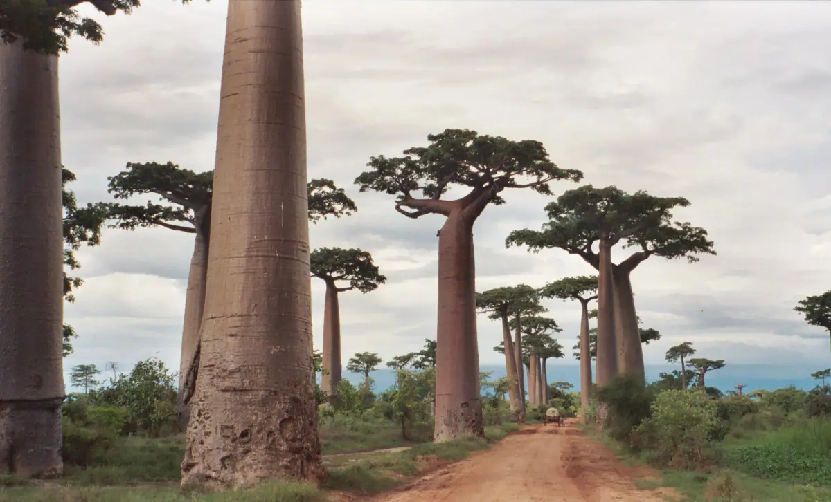
The Avenue of the Baobabs, 45 minutes north of Morondava on a dirt track, is the image that sells Madagascar to the world — and it still delivers in person. These are Adansonia grandidieri, the slender, bottle-trunked giants that can live for many centuries and reach 30 metres. Come at sunset, when the light goes copper and the trunks glow like pillars, and continue a few minutes further to the Baobab Amoureux, a pair of trees that have grown into a single twisted embrace. Arrive early or late in the day; midday light flattens the drama and the dust.
Further north, reachable by a long and famously rough drive from Morondava via Belo-sur-Tsiribihina, the Tsingy de Bemaraha Strict Nature Reserve is Madagascar at its most surreal. This UNESCO-listed plateau is a forest of razor-edged limestone needles, formed by millennia of rain dissolving the rock into fissures, caves and pinnacles. Access is essentially limited to the dry season, roughly April through November, and most visitors arrive by pirogue along the Manambolo River gorge before climbing into the Grands Tsingy on boardwalks and steel cables. Two to three days are needed to do it justice.
Break the journey at Kirindy Forest, a patch of dry deciduous woodland that is one of the most reliable places in the country to see the fossa, Madagascar's largest predator, along with several nocturnal lemur species. Night walks here are excellent. This whole western circuit is hot, dusty and remote; a private 4x4 with a driver is close to essential, and the best conditions run from May through October.
Rainforest Country: Andasibe-Mantadia and Ranomafana
Andasibe-Mantadia National Park, about three hours east of the capital along a paved highway, is where most travellers hear their first indri. The indri is the largest living lemur, a black-and-white animal that looks like a small bear and sings a wailing, whale-like call that carries for kilometres through the mist. The Analamazaotra sector is the reliable place to find family groups in the morning; the larger Mantadia sector, further in, adds diademed sifaka and a wilder, steeper hike. Night walks around the reserve edges turn up mouse lemurs, chameleons and the extraordinary satanic leaf-tailed gecko.
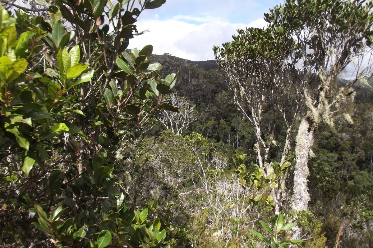
South along the RN7, Ranomafana National Park protects a tangle of steep, cloud-hung ridges that shelter twelve lemur species, including the golden bamboo lemur, a creature only confirmed by science in the late 1980s. The park is wet, green and genuinely atmospheric; guided hikes run from a few hours to a full day, and the effort is rewarded with Milne-Edwards' sifaka leaping between canopy trees and an orchid and fern collection that never stops surprising. The village below has warm thermal pools where you can soak the mud off your boots.
This is rainforest, so rain is not a possibility but a certainty — the east coast catches moisture year-round, and Andasibe sits at altitude, so bring layers, a proper shell and leech socks in the wetter months. Guides are compulsory in both parks and are worth every rupee of their fee; they spot things you would walk past a metre away.
The Arid South: Isalo, Anja and the Spiny Forest
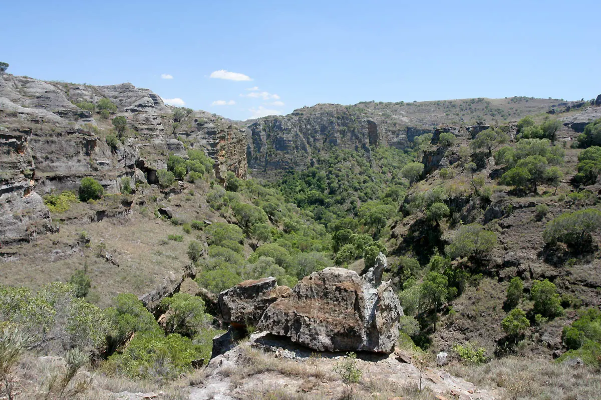
Isalo National Park is the south's showpiece: a sandstone massif of ruined-looking canyons, palm-lined oases and natural swimming pools carved into the rock. The classic routes lead to the Piscine Naturelle, the Piscine Bleue and the Canyon des Singes, past ring-tailed lemurs and Verreaux's sifaka that bound sideways across the boulders. Finish the day at La Fenêtre, the Window of Isalo, where the sun drops through a natural rock arch and the whole escarpment turns violet. Hikes range from two hours to three days; a mandatory local guide arranges everything, and it is roughly a seven-hour drive from the capital or four from Fianarantsoa.
Just south of Ambalavao, the Anja Community Reserve shows what community-run tourism can look like: three granite outcrops, a forest of fig and tapia, and troops of habituated ring-tailed lemurs that lounge obligingly on sun-warmed rocks. It is a two-hour stop and one of the most photogenic in the country. Further south still, near Taolagnaro, the Berenty Reserve offers close encounters with dancing Verreaux's sifaka in a pocket of spiny forest, where octopus trees and sisal plantations frame the lemurs.
The far southern corridor around Toliara and Ifaty preserves remnants of that same spiny forest — a bizarre, thorny world of cactus-like plants found almost nowhere else — with the Reniala reserve and the Zombitse-Vohibasia park as accessible stopping points. Be prepared for genuine heat, long rough drives and very basic roads; flying into Toliara or Taolagnaro saves two exhausting days each way.
The Far North: Nosy Be, Ankarana and Amber Mountain
Nosy Be, Madagascar's largest and most developed island, is the reason many travellers come north. Its capital, Hell-Ville, is a scruffy, cheerful port, but the real life is offshore: the Lokobe Strict Reserve still shelters black lemurs, Nosy Komba's forest is full of habituated troops that clamber through village trees, and Nosy Tanikely is a protected marine reserve with reef fish and turtles in water clear enough to snorkel from the beach. Nosy Iranja, two islands joined by a sandbar that appears and vanishes with the tide, is the classic day trip, with nesting turtles offshore.
Diving and marine life give the north its pull in the dry months. Whale sharks cruise the plankton-rich channels between roughly October and December, while humpback whales pass through on migration from around August into September. On the mainland, Diego Suarez — officially Antsiranana — is the base for two very different reserves. Ankarana Special Reserve protects tsingy limestone, cave systems with underground rivers, crowned lemurs and roosting bats, while Amber Mountain National Park, an hour inland, is a cool, fern-draped rainforest of waterfalls, endemic chameleons and the tiny Brookesia leaf chameleons that fit on a fingernail.
The north is the hottest and driest region in the country, so the May-to-November window is by far the most comfortable; December to March can be punishingly humid. Flying from the capital to Nosy Be or Diego Suarez turns a two-day road ordeal into an hour in the air.
Whales and Wild Coast: Île Sainte-Marie, Masoala and When to Go
Île Sainte-Marie, also called Nosy Boraha, lies off the east coast and has two distinct personalities. Between roughly July and September, humpback whales pour into the surrounding channel to calve, and boat trips put you within respectful distance of animals that breach close enough to soak the deck. The rest of the year the island is quiet: a pirates' cemetery overgrown with vines, vanilla plantations, and the tiny neighbouring island of Île aux Nattes, where you can wade across at low tide and forget about roads entirely.
Far wilder is Masoala National Park on the north-east coast, the largest protected rainforest in the country, reachable only by boat or light aircraft via Maroantsetra. Access is expensive and weather-dependent, but the payoff is primary forest spilling onto empty beaches, the island of Nosy Mangabe with its aye-aye and ancient rock carvings, and humpbacks in the Bay of Antongil during the same July-to-September window.
Timing shapes every Madagascar itinerary. The broad dry season runs from about April or May through October and November, and it is essential for the west, the south and the deep south tracks; the RN7 corridor is at its best from May to October. December to March is hot, wet and carries cyclone risk, though it is also when the landscape is greenest and prices are lowest. Expect big distances, slow roads, domestic flights that sell out, limited ATMs outside the cities, cash in local ariary, and guides who are mandatory in nearly every national park. Pack malaria precautions for coastal areas, and plan fewer stops than you think you need.
Frequently asked questions
How many days do you need in Madagascar?
Ten to fourteen days is the practical minimum for a single region, and three weeks is what it really takes to link the west, east and south without spending every second day in a vehicle. Roads are slow and internal flights are limited, so plan two or three bases rather than a long checklist. A common first trip pairs Antananarivo and Andasibe-Mantadia with the Avenue of the Baobabs, or follows the southern RN7 route through Ranomafana and Isalo.
When is the best time to visit Madagascar?
The dry season from roughly April or May through October or November suits most of the country, and May to October is the sweet spot for the west, the south and the RN7. Humpback whale watching peaks from July to September along the east coast and around Île Sainte-Marie, and whale sharks are most often seen in the north from about October to December. December to March is hot, humid and cyclone-prone, especially on the east coast.
What are the absolute must-see attractions in Madagascar?
For a first visit, the Avenue of the Baobabs near Morondava, the Tsingy de Bemaraha Strict Nature Reserve, Andasibe-Mantadia National Park for indri, Ranomafana for its cloud forest lemurs, Isalo National Park in the south, and the beaches and reefs around Nosy Be and Île Sainte-Marie cover the greatest hits. Ambohimanga Royal Hill near the capital adds the country's royal history in a single morning.
Do you need a guide and is Madagascar safe to travel around?
Guides are compulsory in virtually all national parks and reserves, and their knowledge of wildlife and trails is what makes a visit worthwhile. Travel between towns is generally safe by day, but roads are rough, rural driving is best left to a professional, and walking around Antananarivo or Toliara after dark is not advisable. Keep valuables discreet, use licensed drivers on long transfers, and treat the country's fady — local taboos — with respect.
How do you get around Madagascar?
Domestic flights connect the capital with Nosy Be, Diego Suarez, Taolagnaro, Toliara, Maroantsetra and Île Sainte-Marie, and they are the biggest time-saver in the country. On the ground, shared taxi-brousses are cheap and slow, while a private 4x4 with a driver is the most flexible option for remote routes such as Morondava to Bekopaka. The RN7 south from Antananarivo is paved and the most comfortable long-distance road; the northern and western tracks are another matter entirely.
Plan it — experiences in Madagascar
Live search, booked directly with trusted providers.
Sort the rest of your trip
Everything for Madagascar, in one place
Stay in Madagascar
Hotels, guesthouses and apartments — compared in one search.
Search hotels
Transfer in Madagascar
Private driver waiting on arrival — no queues, no surprises.
Book a transfer
Stay online in Madagascar
Travel eSIM — data the moment you land, no roaming bills.
Get an eSIM