Kiribati is a country that exists mostly as horizon: 33 low coral atolls scattered across an ocean so vast that all its land put together would barely cover a small city. What you find when you land is not resorts and beach clubs but maneaba meeting halls, rusting wartime bunkers, tide flats alive with bonefish and lagoons that glow turquoise against the reef. This is a place to slow down, ask permission, and let the atoll set the pace.
Betio and the Wartime Legacy of Tarawa
Betio occupies the western tip of Tarawa and is joined to the rest of South Tarawa by causeway, so you can reach it on an ordinary minibus ride. In November 1943 this narrow sliver of sand was the scene of one of the fiercest battles of the Pacific War, fought over roughly three days across a piece of land you can walk end to end in half an hour. Today it is also one of the most densely packed strips of land in the Pacific, where washing hangs on lines strung between coconut palms and children play football beside concrete gun emplacements.
The wartime traces are everywhere and completely unguarded. Red Beach, where the landings came ashore, is now just a beach where outrigger canoes are pulled up at the tideline. Inland you will find Japanese command bunkers sunk into the coral, a big coastal defence gun still pointing out over the reef, the remains of a Japanese cemetery, and a memorial to the marines who fought here, marked by a flagpole and a low white wall. Hiring a local guide — easily arranged through guesthouses on South Tarawa — turns a scatter of concrete into a coherent story, and is the respectful way to visit sites that sit inside people's gardens and villages.
The lagoon itself holds another layer of the same history. Several wrecks lie in shallow, bathtub-warm water close to Betio, including the rusted remains of Japanese vessels and landing craft, and snorkelling over them on a calm high tide is one of the most unusual things you can do in Kiribati. Visibility inside the lagoon is limited by sand and tide, so the clearest days come with the neap tides of the trade-wind months. There are only a few dive operators in the country, all based around South Tarawa, so arrange equipment and boats well before you arrive rather than assuming you can walk up and book.
South Tarawa: Bairiki, Bikenibeu and the Causeway Capital
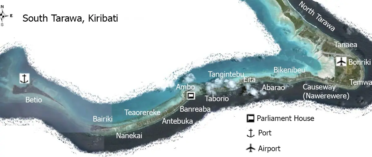
South Tarawa is a chain of islets stitched together by causeways and bridges into a single ribbon of road, and riding it end to end is the easiest introduction to the country. At Bairiki you reach the seat of government, where national ceremonies are staged and where the parliament building, the Maneaba ni Maungatabu, borrows the high thatched form of a traditional meeting house. Nearby you will find the offices of the president and the ministries, plus the modest squares where Independence Day on 12 July fills the road with dancing, marching and colour.
Further east, Bikenibeu is home to Te Umanibong, the national cultural centre and museum, and it is the single best stop for understanding what you are looking at elsewhere in the country. Inside are shark-tooth weapons and coconut-fibre armour, model sailing canoes, dance costumes of pandanus and feathers, woven mats, fishing gear made from shell and bone, and wartime objects recovered from the lagoon. A short walk away is the large Bikenibeu maneaba, and the grassy lagoon front where families gather in the late afternoon.
The real pleasure of South Tarawa, though, is the road itself. Minibuses rattle the length of it for a handful of coins, stopping wherever someone raises a hand, and the scenery shifts constantly: reef flats where women net fish in knee-deep water, the long causeway at Ambo where the current rips through at tide change, the tight cluster of shops and stalls of Teaoraereke, and finally the airport strip at Bonriki. Sailors and anglers line the lagoon side at dusk, and the sunsets over the water are worth planning your day around.

North Tarawa: Villages, Maneaba and Life Without Cars
North of the airport, Tarawa changes character completely. The islets of Buota, Abatao, Tabonibara, Nabeina, Tabiteuea, Notoue, Taborio and Buariki run north in a thin line, and beyond Buota there are no cars, almost no shops and no crowds — just footpaths under coconut palms, pig pens, breadfruit trees and the sound of the reef on both sides. Most visitors reach North Tarawa by local boat from Bikenibeu or by taking a bus as far as the road goes and then walking.
Each village centres on its maneaba, a great thatched meeting hall raised on a base of coral slabs, with a low platform reserved for elders and a strict seating order that visitors should never assume they can choose. Sleeping houses, or bouti, are small, airy and raised on stilts, and the whole settlement is shaded by palms. In Abatao there is a modest cultural site, Tabon te Keeke, where a traditional meeting house, old tools and wartime relics have been gathered together, and where you can get a sense of how these islands were built and lived in long before the causeways.
This is also the best place in Tarawa for birdwatching and quiet lagoon walks. Terns and frigatebirds work the flats, herons stalk the shallows, and at low tide you can wander out across sand and rubble to watch women glean shellfish and octopus from the reef. Turtles still nest on some of the outer islets. Do not treat the villages as an attraction to be photographed at will: ask before taking pictures, dress modestly with shoulders and knees covered, remove your shoes before entering a maneaba, and never step over someone's outstretched legs or touch a person's head.
Kiritimati: The World's Largest Coral Atoll
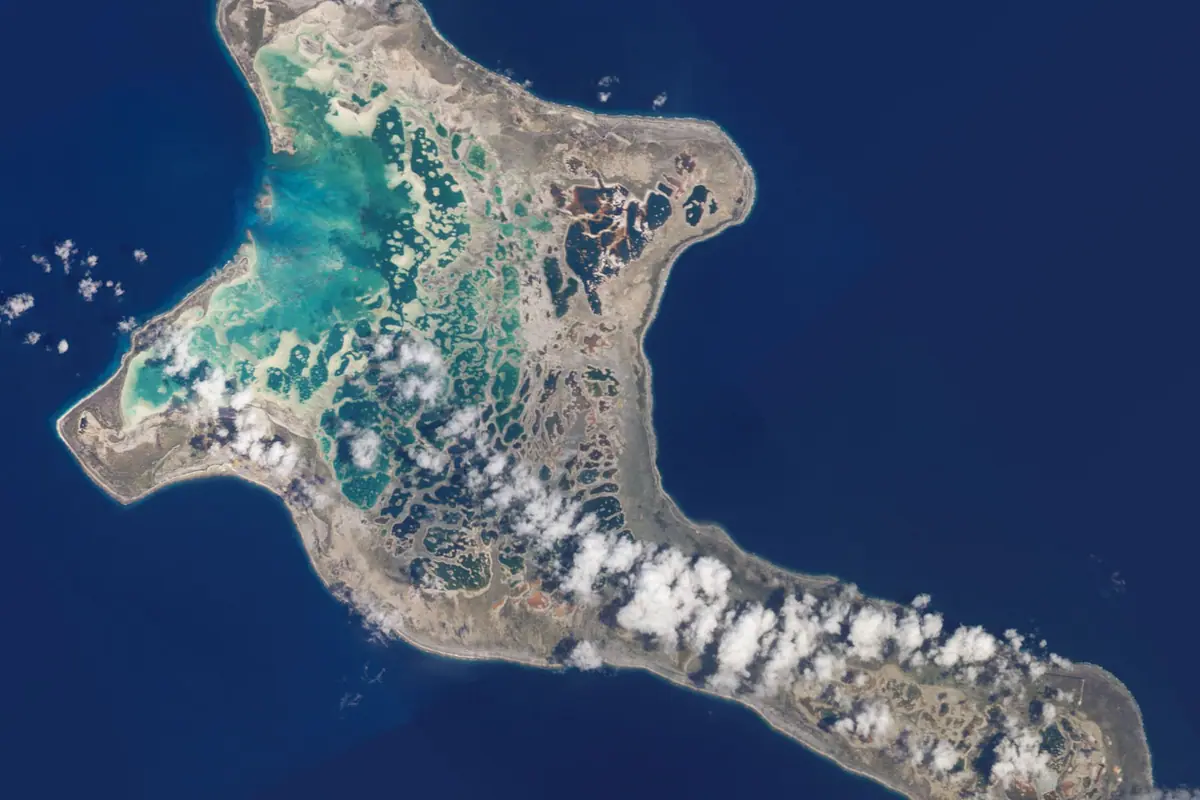
Kiritimati, better known as Christmas Island, lies far to the east in the Line Islands and is the largest coral atoll on earth by land area. It sits just west of the international date line in the UTC+14 zone, which makes it one of the first inhabited places on the planet to see each new day — and the first to greet the new year, an occasion locals celebrate properly. The main villages are London, Tabwakea, Banana and Poland, strung along the road from the airport, and life here is even slower and more spread out than on Tarawa.
The atoll's great set piece is its wildlife. Cook Island Islet, a small sanctuary in the lagoon, hosts a huge colony of sooty terns that rise in a shrieking cloud when disturbed, along with frigatebirds, boobies and tropicbirds; nearby islets such as Motu Tabu and Motu Upua are also protected nesting grounds. On land, look for the endemic Kiritimati warbler, known locally as the bokikokiko, a small brown bird found nowhere else, and for bristle-thighed curlews and wandering tattlers on the flats. Early morning and the two hours before dusk are when the colonies are at their most active and the light is kindest.
Anglers come from across the world for the bonefish that patrol Kiritimati's vast, wadeable flats, along with trevally, milkfish and triggerfish. Fishing is almost entirely catch-and-release and is done with local guides who pole skiffs across the lagoon and out to the ocean-side bays; this is technical sight-fishing that rewards competent casters, but beginners can be taught. Even if you never lift a rod, the flats themselves are extraordinary — ankle-deep water, hard white sand, and nothing on the horizon but lagoon and sky. Bring high-factor sun protection, wading boots and plenty of water; there is very little shade out there.
The Phoenix Islands and the Outer Gilberts
The Phoenix Islands Protected Area is the reason many divers dream about Kiribati. Covering an expanse of ocean larger than many countries, it was inscribed as a World Heritage site in 2010 for reefs that have escaped most of the bleaching and fishing pressure seen elsewhere, with dense coral, clouds of reef fish and healthy shark populations. Kanton, also called Abariringa, is the only inhabited island in the group, home to a few dozen people and an airstrip, while Orona, Enderbury and Nikumaroro are effectively uninhabited. Access is the hard part: there are no regular tourist services, only occasional expedition and research vessels, so this is a destination for the very patient and the very flexible.
The outer Gilbert Islands are far easier to reach on the domestic air network and inter-island ships, though schedules shift constantly. Abemama is famous as the place where Robert Louis Stevenson stayed in 1889, writing about the island's ruler Tem Binoka in his Pacific travelogue; you can still see the site of the old royal compound at Tabontebike and the king's tomb. Butaritari, the greenest and wettest of the group, is scattered with Japanese wartime relics and a seaplane base, and has superb lagoon snorkelling. Marakei is unusual for its two separate lagoons, Banaba rises to the country's highest point at around 81 metres above a landscape scarred by a century of phosphate digging, and Nikumaroro, once known as Gardner Island, draws a steady trickle of visitors intrigued by the fate of the aviator Amelia Earhart.
Practicalities matter enormously out here. Domestic flights are small, infrequent and quick to fill, so confirm seats early and build slack into your plans. Island guesthouses are basic but genuinely welcoming, food is limited to what the reef, the coconut palm and the shop can provide, and you should carry any medication, batteries or specialist gear you need. Take cash, be ready for days of waiting, and accept that the atolls, not your itinerary, decide the timetable.
Culture, Food and How to Time Your Visit
Kiribati's culture is not staged for visitors, which is precisely its appeal. Traditional dance, te mwaie, ranges from the seated, gesture-perfect movements of women to vigorous standing routines for men, often performed at maneaba gatherings and on national occasions; you may also come across te buki wrestling and te kabane canoe racing. Crafts are still practised daily — pandanus mats, thatch, baskets, shell jewellery and the model canoes sold in Tarawa — and buying directly from makers is both welcome and useful. If you are invited to a maneaba, dress modestly, leave your shoes at the edge, sit where you are shown, and stay quiet while elders speak.
Eating here is simple and satisfying. Karewe, the fresh sap tapped from the coconut flower, is drunk sweet in the morning and lightly fermented by evening; boiled down and sweetened it becomes kamaimai, a dark syrup used on pancakes and rice. Look for bwiro, breadfruit preserved in pits wrapped in pandanus leaves and roasted over embers, and te babai, giant swamp taro grown in dug pits and served with coconut cream. Fresh tuna, parrotfish, reef squid and shellfish come off the water daily, usually grilled or simmered in coconut milk and eaten with rice.
The trade-wind months from roughly May to October bring the most comfortable conditions: lower humidity, more reliable sunshine and breezier evenings with temperatures in the high twenties. November to April is hotter, stickier and wetter, with heavy showers and occasional storms, though rain falls in every month and drought years are a real feature of atoll life. Independence Day on 12 July and the November commemorations on Tarawa are the liveliest times to be in the country. The currency is the Australian dollar and ATMs are scarce outside South Tarawa, internet is limited and often satellite-based, so bring cash, download what you need, and pack modest clothing, reef-safe sun protection and a good pair of shoes you do not mind soaking.
Frequently asked questions
What are the must-see landmarks in Kiribati for a first-time visitor?
Start on South Tarawa: the wartime bunkers, Red Beach and memorials at Betio, the parliament building and Bairiki Square, and Te Umanibong, the national cultural centre and museum at Bikenibeu. Add a boat or walking trip into North Tarawa for maneaba meeting halls and traditional village life. If time and flights allow, Kiritimati in the Line Islands offers Cook Island Islet and its seabird colonies plus the world's largest coral atoll landscape.
When is the best time to visit Kiribati?
The trade-wind season from around May to October is the most comfortable, with lower humidity, more sun and daytime temperatures in the high twenties. November to April is hotter, more humid and wetter. Rain is possible in any month, and Kiribati experiences periodic droughts, so pack for sun and sudden showers regardless of when you travel.
How do I reach Kiritimati and the Phoenix Islands?
Kiritimati is served by a small number of weekly flights and is a long hop east of Tarawa, so book well ahead. The Phoenix Islands have no tourist infrastructure at all and can only realistically be visited on occasional expedition or research voyages, usually arranged many months in advance. For everything outside Tarawa and Kiritimati, expect infrequent domestic flights and inter-island ships with flexible schedules.
How long should I spend in South Tarawa?
Two to three full days covers Betio's wartime sites, the cultural centre at Bikenibeu, the causeway drive and a half-day trip into North Tarawa. Adding a fourth day lets you snorkel the lagoon wrecks and slow down to atoll pace. Most travellers combine Tarawa with a longer stay on Kiritimati or one of the outer Gilbert Islands.
What should I know about etiquette and practicalities in Kiribati?
Dress modestly, especially in villages, with shoulders and knees covered and swimwear kept to beaches. Remove your shoes before entering a maneaba, never touch someone's head or step over their legs, and always ask before photographing people. Bring cash in Australian dollars, since ATMs are limited outside South Tarawa, and do not rely on fast internet or on shops stocking specialist gear.
Plan it — experiences in Kiribati
Live search, booked directly with trusted providers.
Sort the rest of your trip
Everything for Kiribati, in one place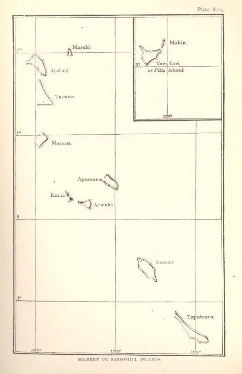
Stay in Kiribati
Hotels, guesthouses and apartments — compared in one search.
Search hotels
Transfer in Kiribati
Private driver waiting on arrival — no queues, no surprises.
Book a transfer
Stay online in Kiribati
Travel eSIM — data the moment you land, no roaming bills.
Get an eSIM