Venezuela squeezes an improbable amount into one country: the world's tallest waterfall thundering off a tabletop mountain, an archipelago of forty-odd sand cays floating in gin-clear Caribbean water, Andean peaks reached by a cable car that climbs to 4,765 metres, and a lightning storm over Lake Maracaibo that has lit the night sky for centuries. The trick is knowing which corners to prioritise, when to go, and how to string them together without wasting days in transit.
Angel Falls and Canaima National Park: Chasing the World's Tallest Waterfall
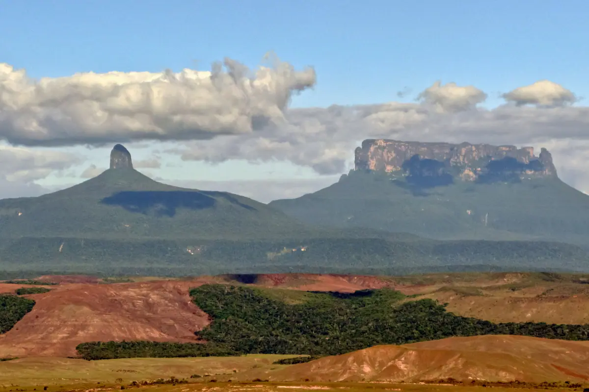
Nothing prepares you for Salto Ángel, the 979-metre plunge of water off the flat summit of Auyán-tepui. It sits deep inside Canaima National Park, a UNESCO-listed expanse of tabletop mountains, savannah and rainforest roughly the size of Belgium, and there is no road in. You arrive by light aircraft from Ciudad Bolívar or Puerto Ordaz, then continue up the Carrao and Churún rivers in a long motorised canoe called a curiara, sitting for hours under a canopy of jungle while the tepuis rise like walls ahead of you.
Most visitors base themselves first at Canaima Lagoon, where the tannin-stained water runs the colour of iced tea and three falls — Salto Hacha and the twin Salto El Sapo — spill across the far shore. You can walk behind the curtain of El Sapo and feel the water punch the rock beside you. From there, the classic three-day trip continues upriver to sleep in hammocks at a camp facing Angel Falls, waking before dawn to watch mist peel off the tepui as the first light catches the water mid-flight.
Timing matters more here than almost anywhere else in the country. December through April is the dry season and the reliable window: rivers are navigable, skies are clearer and the falls run strong. From May to November the water can shrink to a thin ribbon and some upriver departures stop altogether. Take cash, a rain shell, high-factor repellent and a dry bag — and remember that the Pemón communities who guide you here are the reason this landscape is protected at all.
Mount Roraima and the Gran Sabana: Trekking to the Lost World
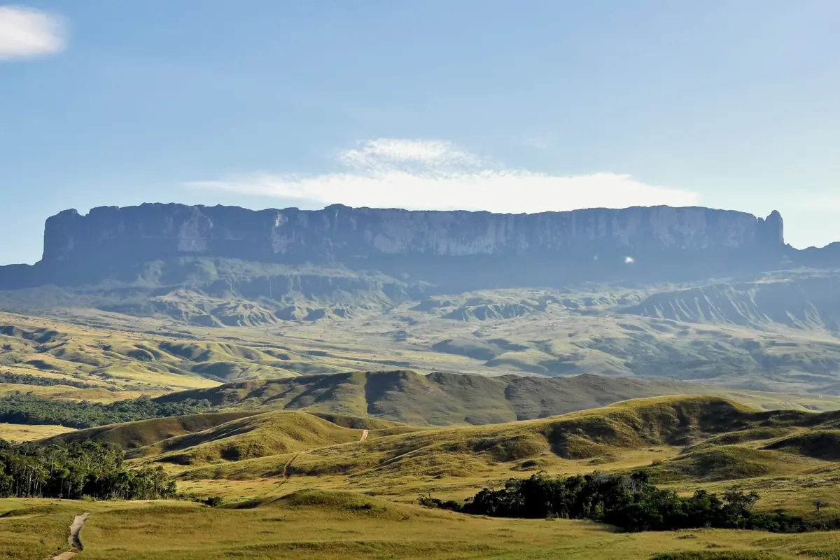
Roraima is the tepui that inspired an entire genre of adventure fiction: a 2,810-metre slab of pink sandstone where Venezuela, Brazil and Guyana meet, ringed by 400-metre cliffs and topped by a maze of black pools, quartz outcrops and carnivorous pitcher plants found nowhere else on earth. Reaching the summit means a six-to-eight-day round trip on foot, starting from the Pemón village of Paraitepui and crossing open savannah, river shallows and a steep final ramp before you step onto what feels like another planet.
Guides from the Pemón communities are compulsory and worth every bolívar — they carry the food, set up camp and know exactly when the weather is about to turn. Nights on the summit drop close to freezing, and the plateau is often wrapped in cloud, so patience is part of the experience. Nearby, the Gran Sabana rewards the journey in its own right: Salto Kukenán, the country's second-highest waterfall, tumbles off a neighbouring tepui; the Quebrada de Jaspe runs over a riverbed of red jasper; and the waterfalls at Salto Pacheco and Salto Kamá, close to the border town of Santa Elena de Uairén, make easy day trips between trekking legs.
Aim for December to March, when trails are firmer and the views actually open up. The wet months turn the savannah to soup and the summit into a wind tunnel. Build in a rest day in Santa Elena before and after, bring broken-in boots, a warm sleeping bag and a headlamp, and treat the altitude with respect — you are sleeping above 2,700 metres.
Los Roques Archipelago: Turquoise Flats and Empty Cays
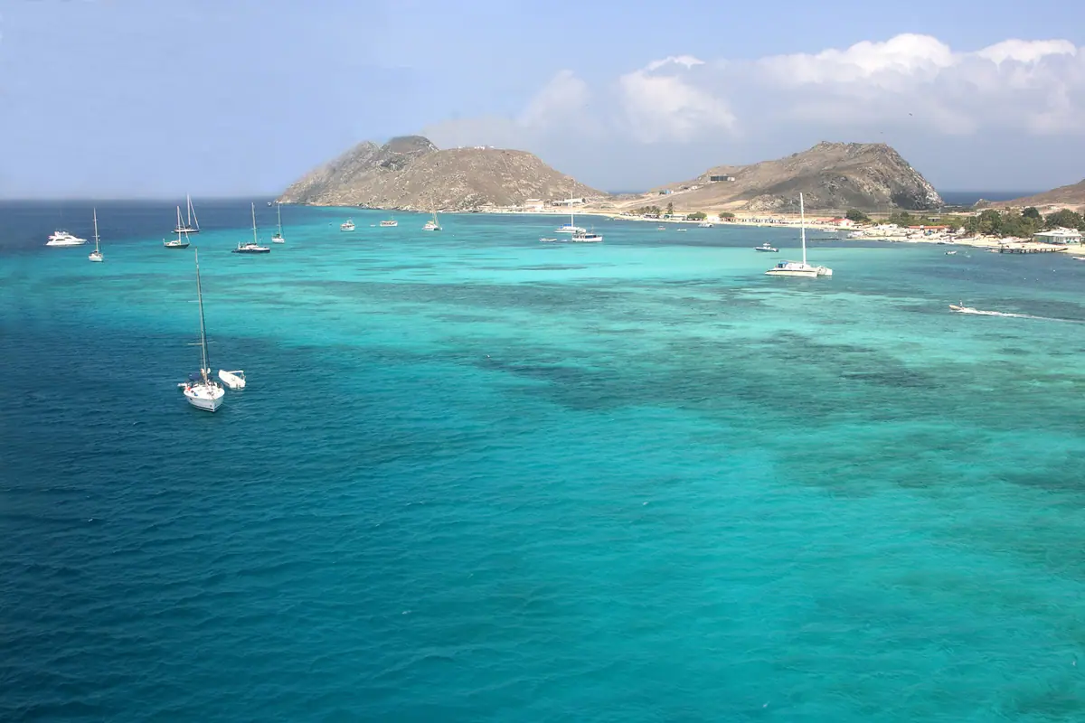
Los Roques is what people picture when they close their eyes and think of the Caribbean: a protected archipelago of more than 40 cays and islets scattered across a shallow lagoon so bright it looks digitally enhanced. Everything centres on Gran Roque, a village of sandy lanes, brightly painted posadas and one small airstrip, where fishermen still head out before sunrise and guesthouse owners cook lobster for dinner. There are no big resorts and almost no cars — you walk barefoot from your room to the dock.
Days are spent on boat taxis hopscotching between cays. Cayo de Agua is the postcard: a curling sandbar that splits two shades of blue, with nothing on it but pelicans. Madrisquí and Francisquí offer calm, waist-deep water and easy snorkelling over patch reefs; Crasquí has shade, driftwood and space to disappear for an afternoon. Beyond the swimming, the flats around the archipelago are legendary among saltwater fly-fishers chasing bonefish, and the steady trade winds on the windward side draw kite surfers from around the world.
December to April brings the calmest seas and the clearest water for snorkelling and diving. From May to November the wind picks up, which is heaven for kiters but can mean choppier crossings. Cays have no shops, so pack water, food and shade; most posadas include boat trips and meals, and the whole archipelago is a national park, meaning permits, limited visitor numbers and a strict leave-no-trace ethos.
Mérida and the Andes: Cable Cars, Paragliding and Páramo Lakes
Mérida is Venezuela's university town turned mountain playground, pinned between the Chama river and the shoulders of the Sierra Nevada. Its showpiece is the Mukumbarí cable car system, which climbs 12.5 kilometres in four stages from the city to Pico Espejo at 4,765 metres — one of the highest cable car rides on the planet. The final station looks straight across at Pico Bolívar, the country's highest peak at 4,978 metres, dusted with snow and glacier remnants.
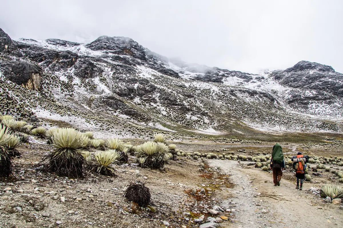
Give yourself a day to acclimatise in the city before riding all the way up; at Pico Espejo the air is thin enough that a slow twenty-minute walk is plenty. Below the snowline, Sierra Nevada National Park hides glacial lakes such as Laguna de Mucubají, ringed by frailejón plants that look like silver-haired sentinels, while the village of Los Nevados is reached by 4x4 or mule along switchback tracks. Closer to town, Jají's cobbled plaza and whitewashed church make an easy half-day escape, and paragliding launches above the valley give you the whole range in one silent sweep.
The dry season from November to March is the time to come: clear mornings, cold, star-packed nights and reliable conditions for hiking and flying. Bring layers regardless of the month — Mérida is spring-like by day and genuinely cold after dark, and the cable car stations climb through several climate zones in under an hour.
Morrocoy, Mochima and Margarita: Venezuela's Caribbean Playgrounds
On the mainland coast, Morrocoy National Park is the classic weekend escape: a shallow bay of mangrove channels and tiny cays off Tucacas and Chichiriviche, reached by boat taxi in twenty minutes. Cayo Sombrero and Playa Mero are the big draws, with white sand, leaning coconut palms and warm, bath-like water, while the Cuare refuge opposite is a nesting ground for flamingos and scarlet ibis. Go midweek if you can — Venezuelan holiday crowds arrive in force on Saturdays and during Semana Santa.
Further east, Choroní and neighbouring Puerto Colombia sit at the edge of Henri Pittier National Park, the country's oldest protected area, where cloud forest tumbles down to a row of beaches and more than 500 bird species have been recorded. Mochima National Park, strung between Puerto La Cruz and Cumaná, offers calmer, quieter islands with good snorkelling and seafood shacks on the sand.
Then there is Isla de Margarita, the largest island, with Playa El Agua and Playa Parguito for swimming and kite surfing, the mangrove tunnel of La Restinga lagoon explored by small boat, the colonial fortress of Castillo San Carlos de Borromeo in Pampatar, and the Basílica de Nuestra Señora del Valle, a pilgrimage site for the whole country. December to April is the sweet spot across all three destinations, with steady sunshine and calm seas.
Coro, Catatumbo and Other Detours Worth the Effort
Coro, founded in 1527, is the oldest surviving colonial town in Venezuela and a UNESCO World Heritage Site, its streets a low grid of ochre walls, wooden balconies and sandy lanes rather than paving. The Catedral de Coro, the Museo Diocesano and the Iglesia de San Francisco anchor a lazy afternoon's wandering — and just outside town, the Médanos de Coro National Park spreads a genuine desert of shifting dunes that can rise more than 30 metres, best explored in late afternoon light.
Far to the west, over the southern reaches of Lake Maracaibo, the Relámpago del Catatumbo puts on one of the planet's great natural spectacles: near-nightly lightning storms that pulse silently across the horizon for hours, generated where warm swamp air meets cold mountain winds. Small boats run visitors out from lakeside docks to watch from the water; the storms peak between September and October, though they occur year-round.
Two more detours reward the curious. In the cool mountains above Caracas, Colonia Tovar is a German-founded village of half-timbered houses, strawberry stalls and mist, while the Waraira Repano cable car lifts you from the capital to Pico El Ávila for a panorama over the city and the sea. And in the northeast, the Cueva del Guácharo near Caripe shelters thousands of oilbirds in a cavern you can walk into, and the Orinoco Delta near Tucupita opens into a watery world of stilt villages run by Warao communities.
Frequently asked questions
When is the best time to visit Venezuela?
December to April is the country's most reliable window: dry-season weather for Canaima and Angel Falls, firmer trails on Roraima, calm seas in Los Roques and clean sunshine along the Caribbean coast. The Andes around Mérida are also at their best from November to March. For the Catatumbo lightning, aim for September or October, and expect heat and afternoon downpours almost anywhere from May to November.
How do you actually get to Angel Falls?
There are no roads. You fly a small aircraft to Canaima, then travel upriver by motorised canoe with a local guide. The standard trip runs three days and two nights, including a stop at Canaima Lagoon and its waterfalls plus a night in hammocks facing Salto Ángel. Departures leave from Ciudad Bolívar and Puerto Ordaz, and operate most reliably between December and April when river levels hold.
How hard is the Mount Roraima trek?
It is moderate to hard rather than technical — six to eight days of walking with a pack, river crossings and a steep final ascent, all at altitude. You camp every night, sleep near freezing on the summit and rely on Pemón guides and porters who carry group gear and food. Reasonable fitness, broken-in boots and a willingness to be cold and muddy are the real requirements.
Should I bring cash to Venezuela?
Yes, and plenty of it. Bring clean, unmarked US dollar bills in small denominations, since card payments are unreliable outside larger hotels and tour operators, and ATMs are not something to depend on. Keep a modest amount of local currency for markets, snacks and small tips, and store the rest in a money belt or hotel safe rather than carrying it all at once.
How many days do I need in Venezuela?
Ten days to two weeks lets you combine two or three regions comfortably — for example Canaima and Angel Falls, Los Roques and a taste of the Andes or the Caribbean coast. Trying to add Roraima on top really requires a full three weeks, because the trek alone takes six to eight days plus travel days on either side. If you only have a week, pick one region and do it properly.
Plan it — experiences in Venezuela
Live search, booked directly with trusted providers.
Sort the rest of your trip
Everything for Venezuela, in one place
Stay in Venezuela
Hotels, guesthouses and apartments — compared in one search.
Search hotels
Transfer in Venezuela
Private driver waiting on arrival — no queues, no surprises.
Book a transfer
Stay online in Venezuela
Travel eSIM — data the moment you land, no roaming bills.
Get an eSIM